
Death Canyon Patrol Cabin
| Trail Features: | Panoramic Views, History | 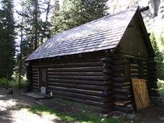 |
|||
| Trail Location: | Death Canyon Trailhead | ||||
| Roundtrip Length: | 7.9 Miles | ||||
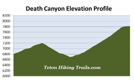
| Trailhead Elevation: | 6807 Feet | ||||
| Total Elevation Gain: | 2040 Feet | ||||
| Avg. Elev Gain / Mile: | 516 Feet | ||||
| Highest Elevation: | 7825 Feet | ||||
| Trail Difficulty Rating: | 11.98 (strenuous) | ||||
| Parking Lot Latitude | 43.65597 | ||||
| Parking Lot Longitude | -110.78128 | ||||
Trail Description:
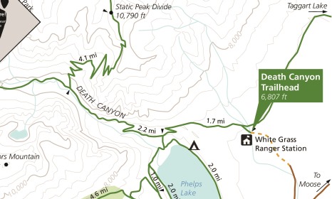
The hike to the Death Canyon Patrol Cabin in Grand Teton National Park begins from the Death Canyon Trailhead. To reach the trailhead from Moose Junction, turn left onto Moose-Wilson Road and drive roughly 3 miles south to the turn-off for the Death Canyon Trailhead. Turn right and drive another 2 miles to the end of the road. Although the first mile is paved, the last mile travels over a fairly rugged gravel road. The park highly recommends using a 4-wheel drive vehicle to reach the trailhead. At the point where the paved road ends there's a small parking area that allows people in 2-wheel drive vehicles to park and walk the last mile to the trailhead.
The hike begins with a moderate climb through a lodgepole pine forest. After walking a very short distance you’ll reach the Valley Trail junction. You should turn left here to continue towards the Death Canyon Patrol Cabin.
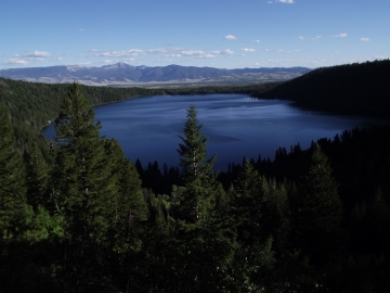 At exactly one mile hikers will arrive at the Phelps Lake Overlook. Resting at an elevation of 7200 feet, this perch stands 567 feet above Phelps Lake and offers outstanding panoramic views. The glacially-carved lake has a surface area of 750 acres, making it the sixth largest lake in Grand Teton National Park. While at the overlook take note of the old-growth Douglas firs nearby, some of which are estimated to be between 300 and 400 years old.
From the overlook the trail travels back down to the valley floor where you'll have access to the lake. As the trail descends you'll enjoy additional views of the lake, as well as some outstanding views of the mouth of Death Canyon.
At just over 1.7 miles hikers will arrive at the Death Canyon Trail junction. A turn to the left will lead you down to a small sandy beach along the northern shore of the lake. To continue towards the Death Canyon Patrol Cabin hikers should proceed straight ahead. From this point forward you'll be traveling along the Death Canyon Trail.
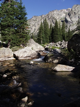 At roughly 2.25 miles the trail more or less enters the mouth of Death Canyon. Soon hikers will begin climbing again, ascending along a moderately strenuous grade while paralleling Death Canyon Creek all the way up to the Death Canyon Patrol Cabin. Views up the canyon, as well as back down the valley towards Phelps Lake and Jackson Hole are quite amazing throughout this stretch.
The dramatic U-shaped valley of Death Canyon, which can also be seen from Highway 89 near the airport, was formed by glaciers roughly 15,000 years ago. The glacial process has exposed the trail to some of the oldest rocks on the surface of the earth, some of which are estimated to be nearly 2.7 billion years old.
Although there's some dispute, the canyon is thought to be named for a member of the 1899 Thomas Bannon topographic survey party who hiked into the canyon and never returned. It's speculated that he may have been killed by a grizzly bear, or possibly a Shoshone Indian.
At 3.7 miles the trail reaches the upper portions of the canyon. The grade moderates dramatically here, and travel becomes much easier.
As you proceed through the canyon hikers should keep an eye out for bears. While black bears are frequently seen in Death Canyon, grizzly bears are becoming more common. You should also be on the lookout for moose feeding on willows near the creek.
At almost 4 miles from the trailhead hikers will arrive at the Alaska Basin Trail junction. At the junction is the historic Death Canyon Patrol Cabin, which was originally built as a barn by the Civilian Conservation Corps in 1935, but became a ranger patrol cabin in 1945. The cabin is now listed on the National Register of Historic Places.
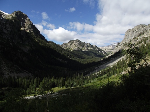
Don't end your hike at the cabin! I highly recommend walking a very short distance up the Alaska Basin Trail for some absolutely stunning views of the upper portions of Death Canyon.